#openstreetmap hidden message in some zoom layer #8 , above berlin
<<known passwords
"Hellohat". "Hellohat12", "Helloh@12", "Hellohat12!", "Helloh@12!".>>

#openstreetmap
80 posts71 participants14 posts today
As you might now, we have an #Android app version of #MapComplete in the works, which makes it even easier to see and edit #OpenStreetMap
After a bit of initial testing, we are opening up the test program to our followers here on Mastodon.
If you want to join the beta testers, send an email to info@mapcomplete.org
Any issues? Head over to https://mapcomplete.org/issues

I wish everyone could write the name of #OpenStreetMap properly.
One word with three capital letters and no trailing S. 

"These features rely on tons of our user-generated data—the fuel of the platform... Crucially to the business, we users perform this crucial labor for free and without any say in the direction of the platform."
And this is why I stopped contributing to #MapyCom (and pretty much all proprietary platforms) and started contributing to #OpenStreetMap and #WikimediaCommons last year.
BIKEPACKING.com · When We Get KomootedFollowing the sale of Komoot to private equity, Josh Meissner explores the broken relationship between corporate capital and our communities...
Continued thread


The other feedback I got was that people should be incentivized to improve OSM…e.g. delivery companies which use OSM could give discounts to mappers, and OSM itself could have some badges and achievements…
In response, I mentioned StreetComplete, presented the heatmap recently added to OSM profiles, and presented the proprietary web services How Did You Contribute to OpenStreetMap? (HDYC) and OSMStats.
But there’s still a lot more that could be done. At the very least, I hope HDYC and OSMStats can be reimplemented as part of osm.org itself…
hdyc.neis-one.orgHow did you contribute to OpenStreetMap?How did you contribute to OpenStreetMap? by Pascal Neis (neis-one.org)
Continued thread
It was pretty funny how that person asked whether there is any way to “reach out to OSM and ask them to only focus on one app”…and I had to gently inform them that OSM (or the OSMF) doesn’t make any apps, that each app was made by independent developers, and that there is no top-down authority dictating who works on what… 
Continued thread
One of the participants said that having multiple apps is too complicated for the average person.
At that point, I…
- had covered #CoMaps (with exercises to practice bookmarking things, editing bookmarks, browsing bookmarks, using the navigation, enabling the Metro layer, and using the search),
- had gotten started with #iD,
- and had mentioned #MapComplete to the complainant in response to a query of theirs.
In the heat of the moment I said that having one app that can do it all would become a pretty complicated one (just look at OsmAnd)…but is that really true if the UI is well-designed…?
#OsmAPP (osmapp.org) aims to be one such “universal app for OpenStreetMap”. I hope it can achieve its goals while still remaining tech-illiterate-friendly…
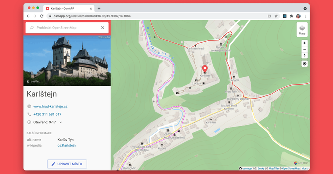
OsmAPPOsmAPPAn open-source map of the world based on the OpenStreetMap database. Features a search, clickable points of interest, in-app map edits, and more!
@imp3tuz If your area is totally unmapped - no streets or buildings - go to osm.org and click Edit. That opens the browser-based editor called iD. Follow the walkthrough.
If you want to add all kinds of details and a gamified experience, see StreetComplete on Android. (The closest thing on iOS is Go Map, until the StreetComplete iOS port is finished.) StreetComplete also supports making photo notes which can be used with iD.
MapComplete is another easy way to add points and notes from your phone and desktop. Uniquely, it also allows you to add photos, ratings, and reviews for places. If it’s too slow on your phone, try the native version.
If you have questions, search wiki.openstreetmap.org. If you still have questions, ask on Fedi or on the OSM XMPP channel 

OpenStreetMapOpenStreetMapOpenStreetMap is a map of the world, created by people like you and free to use under an open license.

This week's episode of the #geomobpod sees Olivia Ragone join the show to discuss her work as GIS data officer at the National Trust and how they use #OpenStreetMap
She talks to @freyfogle about the challenges involved in mapping the UK's historic sites and trails and delves into the role of open data in her work.
Enjoy:
thegeomob.com296. Olivia Ragone: OpenStreetMap at the UK's National TrustGIS officer at the National Trust, Olivia Ragone, joins to discuss the use of OpenStreetMap at NT
Continued thread
The workshop mostly had people from non-IT backgrounds, so I was amazed by how enthusiastic they were - much more so than the usual tech crowd I teach.
They were residents of Nārāinā Village, which is somehow missing on every map, #OSM included. I guess the prospect of rectifying that was at least partially responsible for the enthusiasm.
Yesterday was pretty hectic. Didn’t sleep well at night, had to do a 4 hour (!!!) #OpenStreetMap workshop from 10:00 to 14:00 in a pretty distant part of the city (Nārāinā), then rush to a whole other edge of town (Noidā) to conduct a mapping party from 16:00 to 19:00…
By the end of it all, I got a fair headache, probably from sleep deprivation. I got home at 21:00, gave the cat some food, and hit the sack immediately.
Continued thread

hmm not clear how to get these to show up in a layer on the OSM apps I have. Found a site that lets you build queries though, so here’s a link to the query result that shows what I added (you need to hit the ‘Run’ button to run the query) https://overpass-turbo.eu/s/28De
Also found this site https://mapscaping.com/urban-foraging-map-for-america/ that has a bunch of fruit trees in my city mapped, but the data seems to live on that website rather than in OSM data.
Or maybe I’m doing it wrong? :)
Curious how difficult it would be to embed a map on a website similar to the second link, and either allow submissions somehow via point-and-click, or provide instructions for adding trees & shrubs to OSM? I think there’s a plugin for WP but ugh
overpass-turbo.euoverpass turboA web based data mining tool for OpenStreetMap which runs any kind of Overpass API query and shows the results on an interactive map.
One neat thing about riding a bike now is that I’ve already stumbled on two new-to-me fruit trees that seem suitable for urban foraging.
Then I was like, wouldn’t it be cool to map these?
Well, OpenStreetMap.org has a method for tagging them, although it doesn’t get used much:
natural=tree
and then since I don’t know the trees’ owners, but it seems OK to grab a piece of fruit, I’ve used a ‘source’ tag which, as far as I can tell, is used to indicate the need for verification, so:
source:foraging=permissive
and then a note=”pear tree” (eg) for the type of fruit. Might add some other shrubs around town as well with natural=shrub ;)
Edits: ok so thank you to the kind folks correcting my noob mistakes :) my understanding now is that instead of ‘source’ being a “someone please source this” it is a way to say “here’s where you can verify this info”. And then instead of a note, better to use either ‘trees’ as a key (not only as a value for natural=tree) and/or add the species, and/or use ‘produce’ as a key. At least the hashtags on this post worked as intended ;P
OpenStreetMapOpenStreetMapOpenStreetMap is a map of the world, created by people like you and free to use under an open license.


I added my first doorbell camera on #OpenStreetMap today with @MapComplete, and I would advise others to do the same in their area!
Doorbell cameras are a growing surveillance measure many are still unaware of. On OSM, there's a tag to mark a camera as being a doorbell camera: camera:type=doorbell. They're especially easy to add via MapComplete.
And it's a wrap! Thanks to the 7 participants, including an attendee from Nepal, for attending the 6th OpenStreetMap #WestBengal Mapping Party in #Siliguri, despite the harsh rain in between.
We hope you will join us again to help make #OpenStreetMap better. Each mapper counts.
Special thanks to #TomTom for sponsoring the meal!

 https://www.weeklyosm.eu/archives/18037
Issue 783 of #weeklyOSM is out. 
涵蓋 #開放街圖 #osm 世界大小事的新一期 weeklyOSM 已經發佈 
Lisez les dernières nouvelles de l'univers #openstreetmap 
Viele Neuigkeiten aus der #osm Welt 
新一期的OSM周刊已经发布
Se ha publicado un nuevo número del semanarioOSM 
最新の週刊OSMが発行されました。
주간OSM 최신호가 나왔습니다 
Тижневик OSM тепер доступний Українською 
@openstreetmap

Zu unseren beliebten Architekturführern der Werkstatt Baukultur #Bonn gibt es jetzt auch eine Übersichtskarte:
https://www.dreiviertelhaus.de/reihen/afb/karte/
(Da geht noch mehr, aber nicht mehr heute…)
Mit Dank an #OpenStreetMap und #uMap!
https://umap-project.org/
Replied in thread


Probably too primitive for a normal (and not offline), but https://kostely.ceplovi.cz/ is created by editing the GeoJSON (or it could be CSV) file in https://git.sr.ht/~mcepl/kostely/tree using https://geojson.io/
kostely.ceplovi.czRománské kostely v Česku


Il existe de très nombreuses façons de contribuer à la base de données cartographiques de #OpenStreetMap chacun à sa manière et selon ses possibilités, de débutant à expert, sans bouger de chez soi ou en allant sur le terrain :
https://wiki.openstreetmap.org/wiki/FR:Comment_contribuer
Pour choisir l'éditeur qui correspond le mieux à vos attentes, voici un tableau comparatif des éditeurs existants :
https://wiki.openstreetmap.org/wiki/Comparison_of_editors