Recent searches
Search options

#severe


"Billy, your socks are different colours. One green and one blue."
"Sorry, Miss. That's because of Mister Trumpet."
"Mister Trumpet?"
"Yes. Mother said he made all the sock markers fall. She was really upset. And then she gave me these socks to put on. I think she needs sock markers to see the colours of the socks."
"I see. Yes, the sock-- stock market falls have been severe. Maybe it was Mister Trump, not Trumpet?"
"Yes, Trump. But she didn't say mister, she said bad words."

weather’s turned severe
adjective no adverb here
what’s that you said, dear?

The #MastoPrompt for Sunday 6 April 2025 is:
The poem or story can include the prompt word or be about the prompt word.
@ me, if you like, or just include the #MastoPrompt tag (to allow people to follow or filter their feeds), or keep your work to yourself - all the options are good as long as you're writing.
If you're including an image please do include alt-text if you’re able to.

EVERY WINTER PRECIPITATION (AND HAIL!):
The past several days have been a smorgasbord of #winter #precipitation falling across the #Northland. That included #snow, #sleet, and #freezingrain.
There was even #hail with a couple #thunderstorms Friday afternoon, including the first #severe thunderstorm warnings for 2025!
#Snowfall is still occurring in some parts this afternoon. That will move out by tonight.


 on March 30, 2025 include 8-inches at Ironwood, Michigan, 6.2-inches in Bergland, Michigan, 5.8-inches Cedar, Wisconsin, 5.3-inches in Ashland, Wisconsin, 5.1-inches in Ontonagon, Michigan, 5-inches in Moquah, Wisconsin, and 4.8-inches in Namekagon, Wisconsin.")


4:50 P.M. #RADAR UPDATE:
A line of #showers and #thunderstorms in central #Minnesota is working its way towards Itasca and Aitkin counties.
This line is not #severe, but expect #lightning, heavy #rain, and gusty #winds.

SEVERE THREAT UPDATE:
Good news! The threat of #severe #thunderstorms has dropped in the #Northland. The #Severe #Thunderstorm #Watch has been dropped on the #Minnesota side, with #Wisconsin likely to come soon.
However, heavy #rainfall is still possible. A #Flash #Flood Watch remains in effect through midnight.


NORTHLAND FORECAST FOR AUGUST 29, 2024:
The #Northland stays #dry Wednesday night with light #winds and lows in the 50s.
A #storm system bring a line of #showers and #thunderstorms from west to east starting Thursday afternoon. Some #storms could be #severe with large #hail, high #winds, heavy #rainfall, and a weak #tornado.
#Temperatures warm to the 70s for highs with a southerly #breeze.
VIDEO: https://www.fox21online.com/2024/08/28/wednesday-evening-northland-forecast-8-28-2024/
NEW SEVERE T-STORM WARNING:
The squall line of #severe #weather continues to move east.
over parts of the #Northland.
A new Severe #Thunderstorm #Warning has been issued, impacting southern Ashland and Iron counties.
Biggest threat remains #winds gusting up to 60 mph, along with #hail up to 1-inch in diameter.

SEVERE WEATHER THREAT:
Meanwhile, we are watching the #radar as the #Northland remains under the threat for #severe #thunderstorms thru Monday night.
A #cap in the #atmosphere may limit when these chances come through, but we should see them by tonight. I would expect the strongest #storms to have large #hail and strong #winds.


2) SEVERE STORMS TONIGHT?
We are watching the radar to our west as #showers and #thunderstorms may reach the northern regions of the #Northland tonight and early Monday morning.
It's possible a few could be strong or #severe with gusty #winds and #hail.
This is no guarantee, but it's possible.
But that's not all...


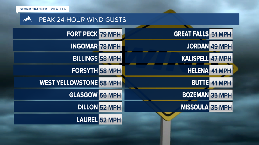
The severe thunderstorm arrived right on time... 76 mph wind gust! The view from outside from my apartment was more like a winter blizzard!
SEVERE THUNDERSTORM WATCH:
A line of #thunderstorms pushing through #Minnesota has prompted a #Severe #Thunderstorm #Watch for parts of the #Northland through the early evening hours.
Greatest threat from these storms will be #winds up to 75 mph and #hail up to 1.5-inches in diameter.


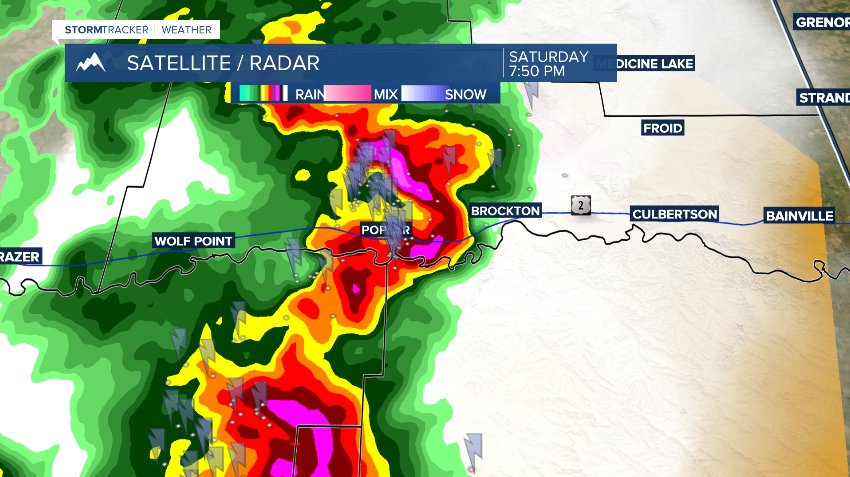
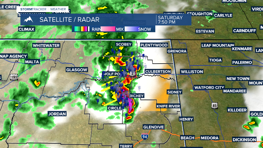
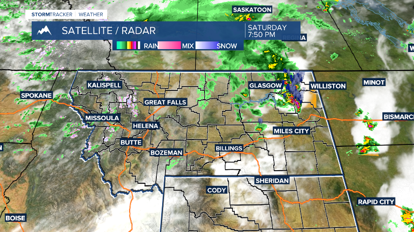
A tornado touched down 13 miles north of Poplar in northeast Montana this evening. The Tornado Warning has expired, but the Severe Thunderstorm Warning continues. Stay safe! I'll have your 7-day weather forecast at 10pm!

Please share her 24-hour automated live channel and websites to monitor when #severe #weather occurs.
It's a small one-person project. Boost I'd you can!
https://www.youtube.com/live/t7up2L1HNLE?si=I-2PCOf699sVphKf
SEVERE THUNDERSTORM WARNING:
The first #Severe #Thunderstorm #Warning of today in the #Northland has been issued for northwest Douglas County until 6:15 p.m.
Locations along Highway 35, including #Superior, could see #winds up to 60 mph and #hail up to 1-inch in diameter.

SEVERE THUNDERSTORM WATCH EXTENDED:
The #Severe #Thunderstorm #Watch that is in effect until 8 p.m. for parts of the #Northland has been extended to cover Carlton, Pine, and St. Louis counties.
Primary threat from the strongest #storms remains high #winds and heavy #rain, with #hail also possible.
